So where would that town have been anyway? My brother says
Nevada cuz it looks like Nevada. How he’d know that I’m not sure. He’s never been to Nevada. ![]()
So where would that town have been anyway? My brother says
Nevada cuz it looks like Nevada. How he’d know that I’m not sure. He’s never been to Nevada. ![]()
Since Radiator Springs is placed on
Route 66, the first thing we have to do is [url=http://en.wikipedia.org/wiki/Route_66]look at its
route[/url].
We can see that R66 does not go through Nevada, so we can discount that.
I’m inclined
to believe it’s dancing around the California/Arizona border. Let’s assume that Mack lost Lightning around
11pm, and Lightning found Radiator Springs approximately fifteen/twenty minutes later. Assuming Mack didn’t
stop, he reached Los Angeles around mid-morning, say 10am. Assuming he traveled at approximately 50-55 miles an
hour the whole time, that’s 11 hours of travel. 11 x 50 = 550 Miles.
This leads me to conclude Radiator
Springs is approximately five or six hundred miles from LA, which would put it in Arizona, not far from the
California border.
I think too much! ![]()
I’d say Radiator Springs is in Carburetor County. ![]() LOL
LOL ![]()
It’s too
bad that yesterday was our last day for showing Cars at work. I would’ve taken a look at the map for ya
tonight.
And yes, RMS, you think too much, but so does Dash. Heheh.
~~=oP
The map doesn’t really say anything of note. There is a “42” near one of the bends in Ornament
Valley, though. Anyone know if that could be used to indicate where RS is?
:? I dunno.
There’s also
a 42 in 42 Wallaby Way, Sydney, Australia. I forget what the significance of it is, and it’s killing me. When
I find out, I’m gonna feel pretty dumb.
~~=oP
The 42 was a reference to “Hitchhiker’s Guide to the Galaxy”. One of
the plots is trying to find the answer to “Life, the Universe and Everything”. This turns out to be 42.
The problem is they never asked about the question to "Life, the Universe and
Everything".
I was wondering if the 42 on the map could be a reference to similar numbers on a real
map of US Highways. If it was, we could work out where RS is.
RMS I believe you hit it dead on. I’ll also add that
I-40 (the one that by passed Route 66) runs closest and parallel to it between the Texas panhandle and the CA/AZ
border. My only feeling is that it’s probly on teh other side of the state say near the AZ/NM border. I say
this for a couple of reasons. First, considering the amount of traffic on the road (in a rather deserted stretch
no less) I’d pin point the time as circa 9:00PM. I also wouldn’t be surprised if it was a bit later when Mack
arrived though I have no direct evidence for this. Also - on those open desert roads I’d say it’s safe to say
Mack was doing AT LEAST 60-65MPH and maybe more if the speed limit there allows. Add in the fact that Lightning
gets turned around and is actually driving in the wrng direction when he initially finds Radiator Springs (notice
he leaves the same way he came) that pushes it back to the AZ/NM area. Also, if it was along the CA/AZ border
then the town would also be within an hour or so of Las Vegas which I highly doubt considering how rural it is.
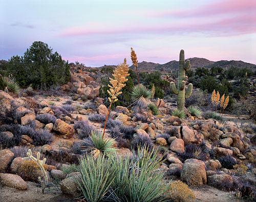
And finally the terain just screams of the mesas and canyons and cacti of the pained desert and rural AZ/NM. It
just fits so perfectly in that space between and north of Phoenix and Santa Fe (your two big cities out there
with little else for hundreds of miles) and was probably (in the good ol’ days) frequented especially by those
headed fr the Grand Canyon.
I’d love to hear Phonecians thoughts on this though being more familiar with
the area. =)
Late Winter/Early Spring, using the timetable of the NEXTEL Cup as an example, hence the Sunset scene when
Lightning won’t let Mack stop would take place around 6:30 or 7pm, when Mack was feeling a bit tired. I reckon
three hours would be enough for Lightning, who was completely alert initially, to go to sleep, as he had no
intention of keeping his promise of staying up all night long.
60-65, but he was still drowsy. I’m sure he’d be going at least a little slower in order to be careful, or he
just couldn’t concentrate to put the force into getting to 65.
in the same direction as Mack was travelling. He initially drives on the Interstate looking for Mack. After
deciding the Peterbilt (Who shall be hereafter refered to as “Joe”, a tribute) to be Mack, he takes the
off ramp, which is 90 degrees to the right of the Interstate. This road is relatively straight. After racing A113
the Train to the crossing and catching up with Joe, they stop at a T-junction. Joe travels right, to places
unknown. Lightning actually takes the left brance of the T. Had he taken the route he came, he’d have reached
the Interstate no problem. He went left, thus undoing the 90 degree turn he made with going on the off ramp, thus
travelling in the same direction as the Interstate, and leading to Radiator Springs.
This said, I think
it’s safe to say RS is somewhere in Arizone.
Here is my 2
cents worth of contribution…
I think Radiator Springs is based in location wise and town wise on
And here is a
picture of a map that has Radiator Springs on
it.
And click here to view a screenshot
of a place in google earth where from the information i have gathered from you guys, is on the Cali/Ariz border
and Route 66 and the I-40 go near it.
That’s the map that was in the movie. Good job! Is that at Pixar HQ?
I do believe that is the Cars Exhibit at
Pixar.
Ok I’m gonna geek it up and over analyze.
Looking at that map showing radiator
Springs , it is on a stretch of Route 66, that runs basically paralell to and is north of HWY 40. It’s also a
narrow gap between them. Amboy is relatively far south of HWY 40.
Ok just east of Flagstaff there is a
stretch where they run Parralell and pretty close to each other. 66 is to the north. it is in a relatively
maoutainess and deserty area. there is a town called Seligman that is there.
It is in the Juniper
Mountains
area.
Seligman.

[/img]
Map of Selgiman
Area
[url=Google Maps
t=opera&rls=en&sa=N&ie=UTF-8&oe=UTF-8&tab=il]Google Map[/url]
Also you will notice in
the google map that just east of Seligman a train track crosses route 66. this is about where ornament valley
would be, and also if you have played the video game there is a train track that crosses Route 66 in Ornament
valley.
Also in
Sleigman
[img]http://www.roadtripmemories.com/images/roadmaveness/Route66-2000/arizona/r15n16.J
PG[/img]
I’m researching some Route
66 stuff…and lowe and behold! Sally’s in Hollbrook
AZ.
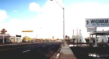
[img:235a
a4a88c]http://www.theroadwanderer.net/images/WA66WIGWAM.jpg[/img]
[img]http://www.th
eroadwanderer.net/images/WA66TEEPEE.jpg[/img]
[/img]
I’m having too much
fun…Sorry!
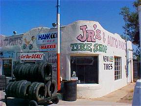
Luigis?
[img]http://www.theroadwanderer.net/66NMex/images/NMMoriartyJRs.jpg
[/img]
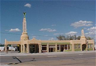
Shamrock
Texas…Ramones?
[img]http://www.theroadwanderer.net/66Texas/images/txShamrockTower2003.jpg[/i
mg]
I’ve created this post on my Web site some months ago to answer a lot of these questions, with
lots of photos:
rwarn17588.wordpress.com/2006/06 … ars-movie/
I
got a lot of this information with Michael Wallis, aka The Sheriff, and my own knowledge of Route 66.
I
can assure you that Radiator Springs is definitely NOT inspired by Amboy, Calif.
Wallis tells me that
Radiator Springs is a composite of several Route 66 towns, including Seligman, Ariz., Tucumcari, N.M., Glenrio,
Texas, etc. But he concurs that the general desert landscape around Radiator Springs is inspired by the area near
the Arizona-New Mexico border, especially west of Gallup.
Thanks route66news, those picture are awesome!
Yeah they really really do look like the Cars places, I’m guessing the makers found these
to.
![http://www.theroadwanderer.net/images/WA66WIGWAM.jpg[/img]](http://www.theroadwanderer.net/images/WA66WIGWAM.jpg%5B/img%5D)